- Joined
- Dec 13, 2014
- Messages
- 43
- Reaction score
- 9
- Age
- 59
- Location
- Hawkes Bay , New Zealand
- Website
- www.tim.co.nz
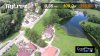
Hi guys, In need of some rather urgent help. A client wants to shoot flood damage to roading and needs an overlay or some easy way to correlate a video to an actual location. His thoughts were to overlay a GPS location on screen (recorded) so that when they spot road damage they can take note of the GPS co-ord's and return to fix it.
This looks very cool and ideal any idea if it can be done with the Inspire data ?
Thanks,
Tim
This looks very cool and ideal any idea if it can be done with the Inspire data ?
Thanks,
Tim