Welcome Inspire Pilots!
Join our free DJI Inspire community today!
Sign up

Orthophotos with Inspire 1

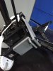
Well the camera mount posted above "sagged" over night from the weight of the camera. Given that it appears the drone can fly without the VPS module I have redesigned the mount to place the sony where the VPS used to be, also using four antivibration balls to mount the sony to the I1.

It is printing now and will be ready in 4 hours time.... I will post pics,
 
  • Like
Reactions: IrishSights
There is the vibration isolated platform. I will connect the camera by means of a ring around the lense as in the above photo, the ring will have posts that use two bolts to fix securely to the top plate.
when I print it in Black it will look awesome.
 

Attachments

  • IMG-20150909-WA0003.jpg
    IMG-20150909-WA0003.jpg
    451.8 KB · Views: 123
  • Like
Reactions: DustyVisor
I have decided to go one step further, I will build the VPS module into the baseplate that I mount the camera on, if I shift it forward an inch, then I still have space for the camera.........
Having opened the case for the VPC module, it looks easy enough to design into my platform. It will have to wait till next week now though as Im busy. But next week I will be away on buisness, so three nights in hotel rooms with nothing to do should yield a cool system.
 
  • Like
Reactions: IrishSights
Just discovered this iOS app at Altizure. It does photogrammetry but takes photos looking down as usual but also looking obliquely at 4 angles giving nice true 3D models. Features are here Altizure.

I will be trying this out next week. Oh and it's free.

Anyone else tried this app?

I tried registering and received
"Thank you for your registration. The service is in beta testing. We will review and activate your account once we have more seats for testing."
 
I just finished up a 100 acre rock quarry session using the beta of maps made easy app. It worked very well. 100 acres flying at 300feet we shot about 500 pix it took 3 batteries. We shot 5 control points with a Trimble GPS unit. I started processing everything in Pix4D before I left the office two days ago and haven't had a chance to see the finished results. When I left the point cloud was sitting at 34million points and looked pretty impressive. I'll post up my sketchfab models when I head in next week. We also have the Aerial Media Pro NIR camera on order. I'll post up some of those results when it arrives.
 
  • Like
Reactions: IrishSights
Just discovered this iOS app at Altizure. It does photogrammetry but takes photos looking down as usual but also looking obliquely at 4 angles giving nice true 3D models. Features are here Altizure.

I will be trying this out next week. Oh and it's free.

Anyone else tried this app?
it looks like it might be a good app. I'm not sure about the use of the 5 photos per point yet as I haven't tried that in the past.
Also internet connectivity in the field is neccesary, and I dont have it. Bummer
 
I just finished up a 100 acre rock quarry session using the beta of maps made easy app. It worked very well. 100 acres flying at 300feet we shot about 500 pix it took 3 batteries. We shot 5 control points with a Trimble GPS unit. I started processing everything in Pix4D before I left the office two days ago and haven't had a chance to see the finished results. When I left the point cloud was sitting at 34million points and looked pretty impressive. I'll post up my sketchfab models when I head in next week. We also have the Aerial Media Pro NIR camera on order. I'll post up some of those results when it arrives.


Here is the ortho and 3D model I generated. The original ortho was 21,000 x 20,0000. Both of these are based strictly off the geo referenced inspire photos. I've not tied in our control points or cleaned any of it up manually. There is room for improvement but I think it turned out decent for a first pass.

Quality Stone by drewid20 - 3D model
 

Attachments

  • quarry_web.jpg
    quarry_web.jpg
    173.4 KB · Views: 91
  • Like
Reactions: m00se
Here is the ortho and 3D model I generated. The original ortho was 21,000 x 20,0000. Both of these are based strictly off the geo referenced inspire photos. I've not tied in our control points or cleaned any of it up manually. There is room for improvement but I think it turned out decent for a first pass.

Quality Stone by drewid20 - 3D model
looks good...... can you zoom in on the web model?
 
As promised here is the NDVI I created with a NIR camera. 100+ acre soybean field. I'm still working on the hole in the middle. Seems the software didn't like the NIR images and couldn't process them correctly because it was hard to match pixels. I'll eventually get that worked out.

561ecfb431ff9a59c07aee13.png
 
  • Like
Reactions: m00se
drewid,

how did you process the NVDI? I assume you had to fly the area twice, once with NIR and once with RGB?
what programs did you use after that ?
 
I have just put my A6000 on my GoPro Mount on a dampening plate on the Inspire. I haven't been flying with it yet. I have used my NIR modified 5.4mm lens GoPro on the mount and got very good orthos from 300ft. I used Dronedeploy beta for the waypoints and got the NIR and visible all in one flight. Hope to try the A6000 this week. Should be able to compensate for the reduced flight time by flying at 400ft esp with 24 MP.

I was pleasantly surprised at how well Photoscan Pro created the ortho from the GoPro as it was quite gusty and you can see the camera plane was off on nearly every shot but it still did the job very well.
5b2b1d7aad3d0cb81a03e05d94d60d91.jpg
8efba2af18a4642582ce2ffde60a4550.jpg

Very cool, I was curious as you do to fix the stabilizer plate to Inspire. I would like to create a similar, but not packed to where fixed it. It was with screws or Scotch tape?
 
This weekend built the aluminum stand with rubber bumpers, Scotch and GoPro parts, and put the Sony A6000 to fly in Inspire.

Very Cool, the Inspire flew really no major problems with the TB48 battery, when used a Canon S100 could a time of 14min, and DJIGO system perfectly depicted the trip time and back safely. With the A6000 could 12min but I realized that when moved could not keep low speeds, and 9-10 min starts appear to battery voltage in yellow and with 30% load, but the return of security bar and safefly say I'm with 3min operations, I was afraid of a power failure and some sensors turn off and happen one flyaway as already reported by other users of Phatons however. the message that appears is the one below every time prompts shift in joystick.

"propulsion output is limited to ensure the safety of the battery"

Someone has seen something?

And while the photos were great to generate the mosaic, but the focus litle blur, For this A6000 someone would have a setup checklist for UAV?
 
Milton, one reason you may have blurred images is the Sony timelapse app focuses on what it sees when it starts. If it is sitting on the ground when timelapse engages it will focus on what is right infront of it, not refocus for each shot. You would need to make sure that the first photo of the timelapse is focused on infinity. I've only done one flight with the A6000 a while ago, I would like to do more but this darn UK weather is pretty limiting and other priorities jump in!
 
Last edited:
I found this interesting site because when using DJIGO it exports recorded telemetry data, which manages the coordinates LAT LONG ALT and also with date and time, however I can not sync photos to the file, despite having filtered in format

LAT, LONG, ALT, DATE, HOUR

DJI Flight Record Converter
 

New Posts

Members online

No members online now.

Forum statistics

Threads
22,293
Messages
210,741
Members
34,501
Latest member
EarthmovingAdelaide