If your goal was to photograph a very large area, I can tell you that going higher maybe won't be the best way to do it.
I had to do ortophotos for someone and tried from 120m (400ft) and from 300m (984ft), well because the one from 300m had a too low resolution it wasn't usable, in the end I made more photos from 120m and stiched them using mapsmadeeasy.com website , it went great.
Now I just did a 366.012 acres (148.043 ha / 0.5719 sq. mi.) ortophoto, my only problem is that I only have just 2 batteries, next week I'll buy another one or two (those ware stiched with Pix4D free - but only for my reference, I will send the original photos to mapsmadeeasy service when I'll make some more as the final area I need to make is 270ha, those photos ware also made automatically using Map Pilot App , the max altitude for autopilots I think it is 120m or 400ft, if you want to go higher I think you will have to fly manually and set the camera to 5seconds timer )
Bellow I will attach the high resolution photos, the I1 was flown manually with camera set on timer - 5s
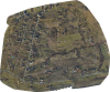
High Resolution stiched by MME (120m / 400ft) (
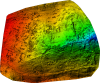
Color terain height profile)
High Resolution stiched by MME (300m / 980ft) (
Color terrain height profile)
PS. I'd love if I could go on automatic flying at about 150m, at that altitude I still get decent ortophotos. But still you can do it manually and looking at the map and try to draw straight lines, and check to overlap the terrain by at least 50% from line to line